
Understanding the complexities of historical battles can often be as challenging as the tactics used in the conflicts themselves. For many, deciphering old battle maps feels like an arduous task clouded with military jargon and faded lines that blend into a canvas of confusion.
The Battle of Iwo Jima, a pivotal moment during World War II, is no exception. Whether you’re a history teacher aiming to engage your class or a war enthusiast hungry for details on this crucial event - deciphering its map is vital.
Iwo Jima was not just an island; it was a battleground where strategies unfolded and heroes emerged under smoky skies on February 19, 1945. A mere speck in the Pacific Ocean became the site where American Marines and Japanese forces clashed violently, leaving an indelible mark on history.
Similar to our breakdown of the Operation Iraqi Freedom map, the battle map of Iwo Jima is a guide that will transport you through time with intricate descriptions – peeling back layers to reveal troop movements, key locations like Mount Suribachi, and defense structures critical to understanding what transpired during those weeks.
By diving into our ultimate guide complete with resources and analysis of antique maps from March 1945’s archives, readers will emerge better informed about one of WWII's most intense episodes—an episode encapsulated within folds of cartography.
Ready for clarity? Keep reading as we unravel history's tapestry together.
Key Takeaways
- Iwo Jima was a small but strategically important island in WWII, captured by U.S. forces to be used as a base near Japan.
- The battle began on February 19, 1945, with American Marines facing strong Japanese defenses such as bunkers and tunnels.
- Maps from the battle detail terrain challenges and troop movements, showing how intense planning shaped the conflict.
- Resources like archives and interactive platforms allow us to explore historic materials related to Iwo Jima online today.
- Studying the Battle of Iwo Jima teaches us about military strategy and honors the bravery of those who fought.
History and Importance of the Battle of Iwo Jima
The Battle of Iwo Jima stands as a pivotal moment in the Pacific Theater of World War II, marking an intense conflict where strategic control and sheer determination clashed on volcanic sands.
This critical engagement not only underscored the indomitable spirit of the American Marine Corps but also shaped the course toward victory over Japan.
Significance of Iwo Jima
Iwo Jima was a small island, but it held great value in World War II. Only 750 miles south of Tokyo, this piece of land became a critical point for the United States Marine Corps. By capturing Iwo Jima, American forces aimed to gain a base close to Japan's main islands.
This would allow them to launch air attacks more easily and provide rescue services for damaged bombers.
US troops faced fierce resistance from Japanese defenders who knew the terrain well. The battle tested both sides' limits with its brutal combat and high stakes. Victory at Iwo Jima meant that America was one step closer to ending the war in the Pacific Theater.
It showed how strategic locations could change the course of history when secured by brave soldiers willing to fight relentlessly for their cause.
Key players and strategies
The battle had many important leaders and plans. American forces were led by Admirals Chester Nimitz and Raymond Spruance, with Marines under the command of Holland Smith. They faced a determined Japanese defense led by General Tadamichi Kuribayashi.
His strategy used the island's rough terrain to its advantage, creating a network of bunkers, tunnels, and artillery positions.
US planners chose an amphibious attack to capture Iwo Jima. Before landing, they bombed the island for weeks in one of the largest pre-invasion bombardments of World War II. Then on February 19, 1945, Marines stormed the beaches as part of Operation Detachment.
It was a tough fight for every yard gained on this volcanic island as both sides battled fiercely over crucial territory.
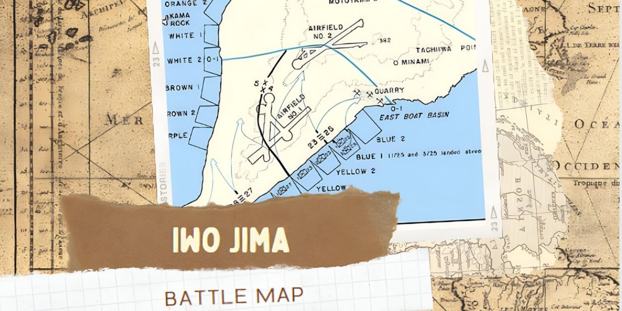
Understanding the Battle Map of Iwo Jima
Delving into the intricacies of the Battle Map of Iwo Jima offers enthusiasts a rare glimpse into the strategic underpinnings and tactical decisions that shaped this pivotal conflict in the Pacific Theater.
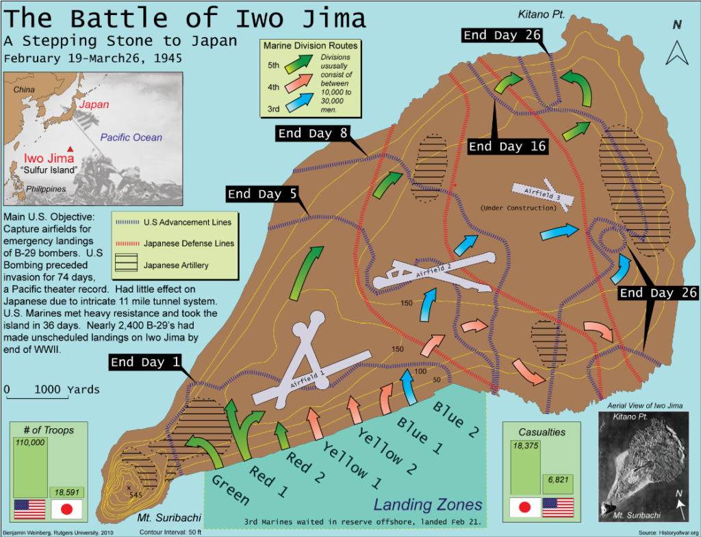
This map, a fusion of topographical precision and military intelligence, becomes an indispensable tool for those seeking to comprehend how every ridge, tunnel, and stronghold bore significance during the relentless combat between American Marines and Japanese defenders.
| Feature | Details |
|---|---|
| Main U.S. Objective | Capture airfields for emergency landings of B-29 bombers. |
| Bombing Campaign | U.S. bombing preceded invasion for 74 days, had little effect on Japanese due to tunnel system. |
| U.S. Forces | 110,000 troops, with Marine Divisions 3rd, 4th, and 5th landing on the island. |
| Japanese Forces | Defense lines and artillery positions indicated, showcasing preparedness and fortification. |
| Landing Zones | Color-coded as Green, Red, Yellow, and Blue, with arrows showing U.S. troop movement. |
| Advancement | Dotted lines with "End Day" markers showing U.S. progress over 26 days. |
| Airfields | Three airfields targeted, with Airfield 1 and 2 being primary objectives. |
| Casualties | 18,375 U.S. and 6,821 Japanese casualties, highlighting the battle's intensity. |
| Geography | Contour interval of 50ft, with Mount Suribachi as a significant feature. |
| Aerial View Inset | Provides perspective on the island's terrain and volcanic nature. |
Detailed description of the map
The map of Iwo Jima is a detailed guide to the historic battlefield. It shows every hill, beach, and valley on this small volcanic island in the Pacific. The engineers who made the map used symbols to mark Japanese defenses such as bunkers and tunnels.
They also noted where American forces landed and fought during World War II.
This battle map even includes contour lines from aerial photos taken before the invasion in September 1944. These lines help us understand the terrain that soldiers faced. By looking at the map, we get a clear view of how tough it was for Marines to capture each part of Iwo Jima from February to March 1945.
Every line and symbol tells a story of bravery and strategy.
Did You Know: Iwo Jima was one of the bloodiest battles in the Pacific Theater, with nearly one-third of all Marine Corps casualties in World War II occurring during this battle? Despite the island's small size, the intense fighting lasted for 36 days.
Order of battle and unit locations
Moving from the detailed map description, let's dive into the order of battle and unit locations. This part is key for understanding how forces were arranged during the Iwo Jima conflict.
- U.S. forces landed on February 19, 1945, with Marines from the 3rd, 4th, and 5th Divisions.
- Each division had specific zones on the beaches of Iwo Jima.
- The northern part of the island was a focus area for securing airfields.
- Maps depicted Marine regiments' movements towards key objectives.
- Japanese defense installations showed strongholds in Mount Suribachi and other strategic locations.
- Unit locations for the U.S. included command posts marked by distinct symbols.
- Enemy unit positions revealed tunnels and underground networks.
- The map illustrated zones of heavy resistance where battles intensified.
- Naval gunfire support locations were plotted to support troop advancements.
- Airfields were marked as primary capture points for American forces.
Enemy defense installations and targets
Understanding the placement of troops and their movements is key to grasping the strategic depth of Iwo Jima. Now, let's delve into the enemy defense installations and targets which played a huge role in this battle.
- The island was heavily fortified with over 11 miles of underground tunnels, linking bunkers and hidden artillery positions.
- Japanese forces constructed more than 1,000 bunkers and blockhouses to strengthen their defensive strategy.
- Artillery placements were strategic, encompassing anti - aircraft guns to defend against U.S. air assaults.
- Around the Volcano Islands, minefields were laid extensively to prevent or slow down U.S. landings.
- Gun emplacements were concealed with natural camouflage, making them hard targets for U.S. forces.
- Multiple cave systems served as both fortifications and storage areas for supplies and ammunition.
- Coastal defense guns guarded the beaches, with heavy concentrations at likely landing sites.
- Mortar positions were scattered throughout Iwo Jima, providing cover fire against advancing Marines.
- Sniper posts took advantage of the rugged terrain to target U.S. officers and disrupt unit cohesion.
- Machine gun nests covered every inch of possible advancement routes on the island's black sand beaches.
Online Resources for Studying the Battle of Iwo Jima
A wealth of digital archives and interactive platforms now offer access to the Battle of Iwo Jima's historical materials, providing both novices and experts with tools for an immersive exploration.
These repositories not only house rare maps and detailed accounts but also allow users to engage with the pivotal moments of this WWII conflict through a click or a tap.
Related products and resources
Studying the Battle of Iwo Jima offers a window into one of World War II's most intense conflicts. For those interested in military history, various resources and products can enhance their understanding of this crucial battle.
- Battle archives provide a rich source of original documents and maps, often with annotations from commanders.
- Specialized books dive into minute detail about the strategies and experiences of both American and Japanese forces.
- The air and gunnery target map is a valuable collector's item that shows key locations targeted during the conflict.
- A rare planning map for one of the landings gives insights into the pre - invasion preparations by U.S. forces.
- The 1943 base map serves as a fundamental reference for changes in geography and troop movements over time.
- Online databases offer digitized versions of maps, diaries, and photographs from the period.
- Reproductions of Joe Rosenthal's iconic photograph are available, capturing the emotion and triumph at Iwo Jima's summit.
- Detailed scale models represent the island and its fortifications, allowing enthusiasts to visualize the terrain tactically.
- Documentaries featuring interviews with veterans bring personal narratives to life, providing an emotional connection to events on the ground.
- Interactive websites permit users to engage with battle maps dynamically, exploring different parts of the island at various stages of conflict.
- Educational tools designed for classrooms help teachers explain the importance of Iwo Jima to new generations.
Rare maps and collections
Rare maps and collections offer a unique look into the Battle of Iwo Jima. They reveal minute details of the island's defenses as known to the U.S. forces.
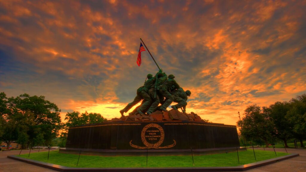
Did You Know: The iconic photograph "Raising the Flag on Iwo Jima" was taken atop Mount Suribachi, which is the highest point on the island and was a key strategic objective for the U.S. forces? The flag raising occurred on the fifth day of the battle and became a symbol of American perseverance and victory.
- The map prepared in April 1945 by the Intelligence Section Amphibious Forces Pacific used distinct symbols to indicate different elements of the Japanese defenses.
- Photomapping platoon employed aerial reconnaissance photos taken since November 1944 to add contour lines, showing natural and man-made landscape features.
- Collectors prize these rare maps for their historical value, highlighting positions and strategies from both sides of the conflict.
- Libraries and museums often have special archives where these maps are preserved, accessible for research and educational purposes.
- Digital archives make some of these rare collections available online, helping people across the world study key aspects of Marine Corps history.
- Maps marked with code names like "Yellow 2" helped Marines understand enemy placements on the god - forsaken island.
- A detailed look at these maps shows how planners estimated manpower expenditure needed to secure until March 26, considering it useless to both Army as a staging base and Navy as a fleet base.
Available categories and items
Military historians, World War II enthusiasts, veterans, and their families often seek out resources to deepen their understanding of historic skirmishes such as the Battle of Iwo Jima. The available categories and items related to this pivotal conflict include a vast array of maps, books, and interactive materials that offer comprehensive insights into the battle's intricacies.
| Category | Items | Description |
|---|---|---|
| Battle Maps | Topographical, Strategic Operations, Naval Support | Detailed maps depicting terrain, troop movements, and support operations. |
| Books and Journals | Military Analyses, Personal Memoirs, Historical Overviews | Print resources giving narratives and scholarly examinations of the battle. |
| Interactive Resources | Virtual Tours, Animated Battle Scenes | Engaging digital content that brings historical events to life for users. |
| Photographic Records | Combat Photos, Aerial Reconnaissance | Images capturing the raw reality of the battle and its surroundings. |
| Multimedia Documentaries | Films, Interviews, Oral Histories | Audiovisual materials providing diverse perspectives on the battle's impact. |
| Research Archives | Official Reports, Dispatches, Battle Assessments | Primary source documents available for in-depth scholarly research. |
| Memorabilia | Replicas, Medals, Uniforms | Collectible items allowing enthusiasts to own a piece of history. |
The breadth of these resources ensures that individuals can find the specific type of information or artifact they are looking for. Each category offers unique insights, whether through the strategic complexities on a map or the personal accounts within the pages of a memoir. Moving forward, the next section delves even deeper into the Battle of Iwo Jima, providing an avenue for reflection on the conflict’s lasting legacy.
Conclusion and Lessons from the Battle of Iwo Jima
The Battle Map of Iwo Jima reveals the intense planning and strategy that went into the historic clash. It shows every detail, from troop positions to enemy defenses. This map was crucial for soldiers on the ground during World War II.
Online resources help us study this battle and its lasting impact today. Reflecting on Iwo Jima teaches us about sacrifice, strategy, and bravery in the face of adversity.
FAQs
1. What does the map of Iwo Jima show?
The map of Iwo Jima, prepared in 1945, shows minute details about the island's terrain and Japanese defenses as they were known to American forces.
2. How was the map created for the invasion of Iwo Jima?
Experts used aerial reconnaissance photos taken over the past month by a photomapping platoon to add contour lines and distinct symbols indicating various elements on this crucial map.
3. Why were two maps used during the battle?
Two maps offered troops on the ground a staggering amount of information with precise data for navigating both ends of the island during intense combat between United States and Japan forces.
4. What is special about how symbols are used on this map?
Distinct symbols on this historic battle map display different features that would have provided planners and participating troops critical intelligence.
5. Did considering manpower expenditure influence how Marines fought at Iwo Jima?
Yes, articles from that period mention consideration given to "expenditure of manpower" when assessing if controlling such a small yet strategic piece was beneficial for staging bases despite being useless to bigger military arms like army or navy branches.
6. Is there an emotional significance tied to these battle maps?
Indeed, these meticulously crafted maps represent where many brave Marines lost their lives fighting—a stark reminder that every line and symbol bears importance beyond just strategic value.


